Off and on rain with scattered storms Wednesday | Flooding and gusty winds possible
AROUND LUNCHTIME, BUT MORE COMING FOR THE LATE AFTERNOON EVENING HOURS. WE’RE NOT GOING TO BE AS WET LATE WEEK. WE’LL HAVE SOME ISOLATED SHOWERS, BUT NOT EXPECTING THE HEAVY DOWNPOURS LIKE WE’RE EXPERIENCING THIS MORNING. UPGRADING EASTER SUNDAY TO AN IMPACT DAYS. WE’LL HAVE RAIN FOR THE MORNING HOURS. SO RIGHT NOW WE HAVE STEADY RAINFALL AGAIN. IT IS REALLY MOVING HERE ALONG THE PARKWAY EAST AND WEST. THIS IS EXTENDING ALSO INTO SOUTHERN PORTIONS OF WESTMORELAND COUNTY ALL THE WAY OUT INTO LIGONIER, MOUNT PLEASANT, EVEN ROSTRAVER DOWN INTO CONNELLSVILLE, UNIONTOWN, PARTS OF FAYETTE COUNTY. SOME OF THAT HEAVIER RAINFALL. THIS IS EXTENDING NOW INTO WASHINGTON. ANOTHER ROUND OF SOME HEAVY RAIN JUST COMING NEAR THE AIRPORT THERE INTO MOON TOWNSHIP, AND ALSO POCKETS OF HEAVY RAIN INTO BUTLER, LAWRENCE AND BEAVER COUNTY. SO ALL OF US HAVE THE RAIN AND WE’RE ALL GOING TO SEE IT SLOWLY TAPER OFF AFTER 7:00, A LITTLE BREAK AROUND LUNCHTIME, A FEW BREAKS IN THE CLOUDS AS WELL, BUT WE’LL SEE MORE SHOWERS TRYING TO DEVELOP AROUND THREE, 4:00 AS YOU MAY BE HEADING HOME FROM WORK, BUT SOME POCKETS OF HEAVY RAIN, SOME THUNDERSTORMS CAN’T BE RULED OUT INTO WESTMORELAND AND FAYETTE. THIS IS AROUND 6:00 THIS EVENING. STILL A LINE OF SOME HEAVY RAIN UP ALONG I-80 THAT EXITS THE AREA INTO THE OVERNIGHT EARLY THURSDAY. STILL COULD HAVE A LINGERING SHOWER, BUT THURSDAY THROUGH THE DAY LOOKS GOOD. EVEN BETTER, WE’LL BE GETTING INTO THE LOW 80S, SO WE SEE THAT DARKER GREEN. THAT’S AN INDICATOR OF POTENTIAL FOR AN ISOLATED THUNDERSTORM. SEVERE THUNDERSTORM TO DEVELOP INTO THE AFTERNOON, ESPECIALLY WITH SOME OF THOSE STRONGER WIND GUSTS AND HEAVY DOWNPOURS. THERE’S YOUR FOUR DAY FORECAST. SUMMERLIKE AIR SETTLES IN THURSDAY, FRIDAY AND SATURDAY. REALLY, SATURDAY IS GOING TO BE A GORGEOUS DAY FOR US AND THAT IS GOING TO EXTEND INTO NEXT WEEK. WE JUST HAVE TO GET THROUGH EASTER SUNDAY MORNING. WE ARE SEEING SOME LOW VISIBILITY AS THAT RAIN PUSHES THROUGH AND TEMPERATURES ARE INTO THE UPPER 50S. STILL A LITTLE BREEZY OUT THERE, BUT THOSE WINDS WILL DIE DOWN AS WE PROGRESS INTO THE AFTERNOON. AS WE LOOK AT YOUR FOUR DAY PLUS FOR MORE FORECAST. FRIDAY IS NOT A WASHOUT OF A DAY. I THINK RELATIVELY QUIET FOR THE PIRATES HOME OPENER. STILL, THAT SMALL CHANCE FOR AN ISOLATED SHOWER TO POP UP. WE’LL SEE SOME RAIN LATE ON SATURDAY. DRY THROUGH A LOT OF THE DAY. TEMPERATURES WILL BE DROPPING ON SUNDAY. IT IS GOING TO GET MUCH COLDER BY LATE MORNING AS THAT FRONT SWEEPS THROUGH. WE’LL HAVE THE RAIN IN THE MORNING. IT WILL BE A LITTLE SOGGY FOR THE EASTER EGG HUN
Off and on rain with scattered storms Wednesday | Flooding and gusty winds possible

The Impact Day continues Wednesday for area-wide rain and the potential for strong storms in western Pennsylvania.Thunderstorms could produce large hail and strong winds. Heavy rain could lead to localized flooding. Severe weather alerts: See current alerts for your county and sign up for alerts to your phone or emailInteractive radar: Track storms as they move through your areaFlood WarningA flood warning is in place for parts of Beaver, Butler, Lawrence, and Washington county until 11 am. Flooding caused by excessive rainfall is expected. These counties have experienced near 1.5″ of rain already making some rivers, creeks, streams, low-lying and flood prone areas go over their banks.Impact Day Wednesday: Off and on rainWednesday is another Impact Day for rounds of rain and storms. The rain will build from south to north through the morning commute. We will see a brief break during the afternoon. Rain and storm chances return for the evening commute.The severe potential appears limited for western Pennsylvania. However, heavy rain and gusty winds are possible again.An Early Easter Look Unfortunately, rain chances linger for Saturday night and Sunday. Most of Saturday looks dry but rain will return late. An Impact Day for Sunday as steadier rain and dropping temperatures expected for the morning hours.
The Impact Day continues Wednesday for area-wide rain and the potential for strong storms in western Pennsylvania.
Thunderstorms could produce large hail and strong winds. Heavy rain could lead to localized flooding.
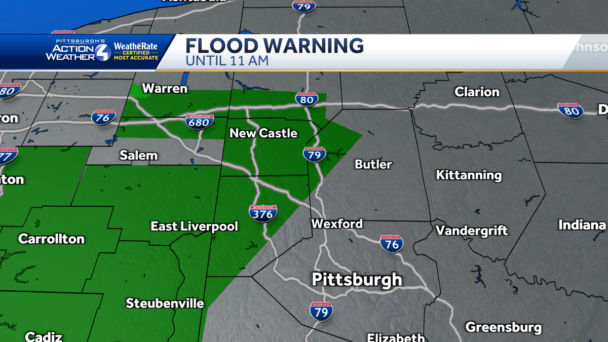
Flood Warning
A flood warning is in place for parts of Beaver, Butler, Lawrence, and Washington county until 11 am. Flooding caused by excessive rainfall is expected. These counties have experienced near 1.5″ of rain already making some rivers, creeks, streams, low-lying and flood prone areas go over their banks.

Impact Day Wednesday: Off and on rain
Wednesday is another Impact Day for rounds of rain and storms. The rain will build from south to north through the morning commute. We will see a brief break during the afternoon. Rain and storm chances return for the evening commute.
The severe potential appears limited for western Pennsylvania. However, heavy rain and gusty winds are possible again.
An Early Easter Look
Unfortunately, rain chances linger for Saturday night and Sunday. Most of Saturday looks dry but rain will return late. An Impact Day for Sunday as steadier rain and dropping temperatures expected for the morning hours.