A slightly more active pattern arrives next week
FORECAST HIGHLIGHTS
-
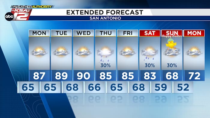
WARMER WEEK: Mid-80s to low 90s, mostly sunny
-
NEXT RAIN CHANCE: Wednesday night, early Thursday
-
EASTER WEEKEND: Possible rain chance, cold front
FORECAST
STARTING THE WEEK AWARM
The upper level ridging sticks around allowing temperatures go back to warmer than normal for much of the work week. The southerly winds also increase which will aid in the unseasonably warm and dry weather in the mid to upper 80s and lower 90s.
MID-WEEK RAIN CHANCE
Wednesday night into Thursday morning will be our next window for rainfall. Showers and a few storms are possible. Any rain would clear out by Thursday afternoon. Rainfall totals are expected to stay on the low-end.
EASTER
While it’s too early to talk specifics, the pattern is hinting at a cold front Saturday evening, paired with a chance for showers & storms. Odds for rain remain low at this time. It is possible that Easter Sunday could be cool and cloudy, depending on the cold front’s timing. Stay tuned for more updates!
QUICK WEATHER LINKS
Copyright 2026 by KSAT – All rights reserved.