Severe weather alert day into this morning with heavy rain continuing to fall and an areal flood warning in place until 7:15 am. AM Rain, PM SunThe heaviest rain will continue early this morning. An Areal Flood Warning is in place for Allegheny, Armstrong, Beaver, Fayette, Indiana, Washington, and Westmoreland County until 7:15am. 1-2″ has already fallen and rain continues to fall this morning. Flooding of rivers, creeks, streams, and other low-lying and flood-prone locations is imminent or occurring.Clouds will continue to decrease through the afternoon and a bit cooler today with highs in the mid to upper 40s this afternoon. Cool weekend with sunshineTemperatures will be knocked back, again, into the 40s to wrap up the work and school week. The weekend will be dry and seasonably cool. Saturday will only be in the 40s before skipping to the mid 50s on Sunday. Skies will be mostly sunny to partly cloudy.A warming trend will take shape for the final days of March. Rain chances return next week as temperatures warm.TODAY – Severe Weather Alert Day: Early morning rain then much cooler with some clearing by the afternoon. High: 49°TONIGHT: Mostly clear and cold. Low 25°SATURDAY: Seasonably chilly and mostly sunny. High: 45°, low: 29°.SUNDAY: Partly cloudy and seasonal. High: 56°, low: 43°.
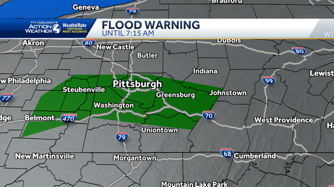
Severe weather alert day into this morning with heavy rain continuing to fall and an areal flood warning in place until 7:15 am.
AM Rain, PM Sun
The heaviest rain will continue early this morning. An Areal Flood Warning is in place for Allegheny, Armstrong, Beaver, Fayette, Indiana, Washington, and Westmoreland County until 7:15am. 1-2″ has already fallen and rain continues to fall this morning. Flooding of rivers, creeks, streams, and other low-lying and flood-prone locations is imminent or occurring.

Clouds will continue to decrease through the afternoon and a bit cooler today with highs in the mid to upper 40s this afternoon.
Cool weekend with sunshine
Temperatures will be knocked back, again, into the 40s to wrap up the work and school week. The weekend will be dry and seasonably cool. Saturday will only be in the 40s before skipping to the mid 50s on Sunday. Skies will be mostly sunny to partly cloudy.
A warming trend will take shape for the final days of March. Rain chances return next week as temperatures warm.

TODAY – Severe Weather Alert Day: Early morning rain then much cooler with some clearing by the afternoon. High: 49°
TONIGHT: Mostly clear and cold. Low 25°
SATURDAY: Seasonably chilly and mostly sunny. High: 45°, low: 29°.
SUNDAY: Partly cloudy and seasonal. High: 56°, low: 43°.