WATCH LIVE RADAR IN VIDEO ABOVE
FORECAST HIGHLIGHTS
-
MORNING COMMUTE: Spotty showers/storms. Use caution!
-
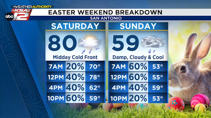
SATURDAY: Cold front arrives midday/early afternoon with showers & storms, turning colder and breezy by late afternoon
-
EASTER SUNDAY: Damp, cool, and breezy
FORECAST
TODAY
The bulk of the rain has moved north of San Antonio through the Hill Country, but the San Antonio metro area could get grazed by the rain through mid-morning.
There’s also a small chance for a few showers this afternoon, but coverage will only be 20-30%. Otherwise, it’ll be warm today with a hig high in the 80s. We’ll have much better rain chances over Easter Weekend…
EASTER WEEKEND
Saturday should begin fairly quiet, warm, and humid. But A cold front will arrive Saturday afternoon, bringing a line of showers and storms, along with breezy north winds.
On Easter Sunday, disturbances in the upper levels will move across the area. This will stir up the potential for more showers. Severe weather is NOT EXPECTED Easter Sunday.
While we can’t guarantee where the heaviest of the rain will fall, it’s best to have a back-up, indoor option for any Easter egg hunts and backyard barbeques…just in case!
Regardless of how long rain sticks around, it’ll be much cooler Sunday! Highs will struggle to get out of the 50s with a stout northerly wind. Plan those Easter outfits accordingly!
QUICK WEATHER LINKS
Copyright 2026 by KSAT – All rights reserved.