4Warn Weather – SATURDAY: Mostly cloudy skies. A chance of showers and thunderstorms. Some could be strong to severe in the afternoon & evening. High: 70.
SATURDAY NIGHT: Mostly cloudy skies, a chance of showers and thunderstorms early. Drying out and breezy overnight. Low: 38.
SUNDAY (EASTER SUNDAY): Mostly cloudy skies and chilly. Breezy winds anticipated. High: 45.
SUNDAY NIGHT: Mostly cloudy skies. Low: 33.
MONDAY: Mostly cloudy skies. A chance of rain showers. High: 49.
After a beautiful end of the week with lots of sunshine and very warm temperatures on Friday, we are bringing wet weather into the forecast, looking ahead into the upcoming weekend.
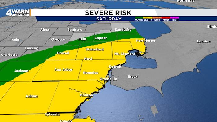
We start the weekend with chances for showers and thunderstorms on Saturday, our first round as you’re waking up on Saturday morning, with another round expected Saturday afternoon into Saturday evening. Some storms could be strong to possibly severe Saturday afternoon and evening as well.
The Storm Prediction Center has placed most of the region under a Slight Risk (2 out of 5) for severe weather to start the weekend. These storms will be along ahead of a cold front that will move through by late Saturday night. Damaging winds of over 60 miles an hour and heavy rainfall will be the primary threats, but an isolated tornado cannot be ruled out. After a chilly start with 30s in the 40s, early on Saturday morning, high temperatures were warm into the upper 60s to near 70° by Saturday afternoon.
If you’re looking to head to the Detroit Tigers game at Comerica Park with the St. Louis Cardinals in town for the weekend, we’ll be on the alert for a rain delay situation or a potential washout due to then
Once the cold front rolls through late Saturday night, we will keep the cloud cover in the forecast overnight, and it will also be chilly. Overnight lows are dropping into the mid-30s by early tomorrow morning.
Colder air moves into the region, looking ahead to the end of the weekend on Easter Sunday, we will keep cloud cover around as well. Mostly cloudy skies can be expected. High temperatures are warming into the low to mid-40s by Sunday afternoon. But once you factor in the winds, expect wind chills to be in the 30s to low 40s for much of the day. With the colder air moving into the region, do not be surprised to see a snowflake or two throughout the day on Easter Sunday.
Rain chances return to the forecast, looking ahead into the start of next week on Monday. Expect chilly temperatures to stick around into the start of the week as well. High temperatures warming into the upper 40s by Monday afternoon.
High pressure builds into the region, and we dry things out looking ahead into the middle of next week. Expect a mixture of sunshine and clouds for Tuesday and Wednesday. High temperatures will remain in the 40s for Tuesday, then we will warm into the mid-50s by Wednesday.
Another chance of rain showers moves into the forecast for Thursday, and temperatures will get even warmer. High temperatures warming into the upper 60s by Thursday. Sunshine returns to the forecast for the end of next week on Friday. Expect high temperatures to remain mild, into the lower 60s by Saturday afternoon.
Copyright 2026 by WDIV ClickOnDetroit – All rights reserved.