SO BESIDES JUST THE TORNADO WARNING, WE’VE GOT INCREDIBLY LARGE HAIL AGAIN WITH HOW LOW THE CLOUDS ARE. A LOT OF TIMES WE GET WARM AIR AND AS THE HAIL FALLS, IT STARTS TO MELT A LITTLE BIT. BUT THESE ARE GOING TO COME OUT OF THE STORM AND PRETTY MUCH HIT THE GROUND. DAVID, YOU’VE GOT A GREAT LOOK AT SOME OF THOSE. YEAH. CAN YOU JUST SEND IN THIS PHOTO FROM THE NORTH SIDE OF OTTUMWA OF THE HAIL? JUST INCREDIBLE HAIL RIGHT THERE. SO THAT IS, YOU KNOW, VERGING ON BASEBALL SIZED HAIL. LOOKS LIKE WITH THIS THUNDERSTORM JUST JUST A MINUTE AGO, CARNEY SENT THIS IN. SO I DO APPRECIATE YOU SHARING THAT PHOTO WITH US. YOU CAN SEE HOW LARGE THAT HAIL IS. SO THAT IS CERTAINLY DANGEROUS. IT’S GOING TO BE DAMAGING. WANT EVERYBODY TO BE INDOORS WITH THIS STORM HERE JUST NORTH OF OTTUMWA AS IT CONTINUES TO MOVE EASTWARD WITH THAT HAIL RISK. I WANT TO SHOW YOU OUR HAIL PRODUCT ONCE AGAIN AS THE STORM CONTINUES TO RACE EASTWARD. IT’S UPDATED ABOUT AN INCH AND A HALF. BUT AGAIN, WE SAW THAT PICTURE HERE HAIL LIKELY UP TO MAYBE TWO INCHES IN DIAMETER. NOT OUT OF THE QUESTION WITH THIS STORM. SO IN ADDITION TO THAT TORNADO RISK, YOU GOT TO TAKE THE HAIL RISK HERE SERIOUSLY A
Iowa weather: Tornadoes, hail, heavy rain all possible in Thursday storms
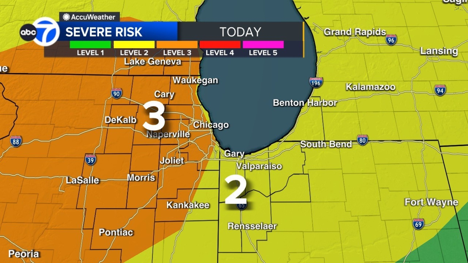
Polk County is among more than three dozen counties under a tornado watch through 8 p.m. Thursday.

Multiple rounds of thunderstorms are moving across Iowa on Thursday afternoon, with more severe weather expected Friday.Interactive Radar | Weather Alerts | Latest forecast | Skycams Active alertsA tornado warning is in effect through 4 p.m. for a portion of southeastern Keokuk and west-central Washington in southeastern Iowa. The National Weather Service says people in that area should take cover and move to a basement or interior room on the lowest floor of a sturdy building. Threats include tornadoes and ping pong ball-sized hail and larger.A tornado watch is in effect through 8 p.m. for about two dozen counties in the southeast quarter of the state. Tama, Poweshiek, Mahaska, Monroe and Appanoose counties are on the far western edge of the watch.A severe thunderstorm warning expired at 3:15 p.m. for portions of central Iowa, including southeastern Polk County, northern Marion County, western Jasper County and eastern Warren County. Threats included damaging winds up to 60 mph with penny-sized hail.A tornado warning for central Wayne County in southern Iowa was canceled around 2:55 p.m.Iowa weather: ‘Incredibly large hail’ reported in Ottumwa areaIllustrating hail size referencesTraditionally, common objects like peas and golf balls and softballs have been used to describe the hail you may see. This image helps with those references.WATCH: KCCI skycam shows moment blanket of fog switches directions over downtown Des MoinesHere’s how to make sure your phone provides severe weather alertsWhen storms are in the forecast, you want to make sure your mobile phone settings allow for alerts that warn you of severe weather.The U.S. Homeland Security Department says to check your phone’s settings and ensure you have “Government Alerts” or “Emergency Alert Messages” enabled.You can keep track of the weather wherever you are with the KCCI app: Apple | Google PlayWe’ll send you weather alerts and you can track live radar right on your phone.Weather Aware: How to make sure your phone provides severe weather alertsToday’s stormsSteady rain brought over an inch of rainfall to central Iowa this morning, helping to keep temperatures on the cool side. This afternoon a surge of warmer air will push into southern Iowa, helping to bring fuel for additional thunderstorms capable of at least some severe weather.Those storms are developing in southwest Iowa as of early this afternoon, and will quickly push eastward throughout the afternoon hours. As the storms interact with the warm and humid air south of I-80, they will likely intensify with at least some risk for severe weather. Large hail and damaging winds will be the main risks, but there will be a low chance for tornadoes as well, especially over southeastern Iowa where temperatures will have longer to warm up.This line of storms should reach the I-35 corridor between 1 and 2pm. While the storms may not be severe as they reach I-35, that will be strengthening and the severe risk will gradually increase as they push to the east.By 5pm, this line of storms should be moving out of central Iowa, taking the risk for severe weather with them. The risk will continue over eastern Iowa for a couple more hours, before cooler and quieter weather takes over for the rest of the evening and the overnight for most of the state.Friday’s storms Another low-pressure system will draw warm, humid air toward Iowa Friday afternoon. Friday’s storms are expected to form later in the afternoon in southern Iowa and northern Missouri. Severe potential is higher Friday, thanks to more energy in the atmosphere and more favorable winds. The highest threat is across southern and southeast Iowa, where storms will spread through into the evening. The main thing to watch is how long it takes the warm, moist air to lift into Iowa from the south and how far north it goes before nightfall. Where temperatures remain cool all day, the severe weather risk be extremely limited, or nonexistent. Tornado safety tipsIf you are in a home, small building, nursing home, hospital, factory, shopping center or high-rise building:Go to a pre-designated area such as a safe room, basement, storm cellar or the lowest building level. If there is no basement, go to the center of a small interior room on the lowest level (closet, interior hallway) away from corners, windows, doors and outside walls. Put as many walls as possible between you and the outside. Get under a sturdy table and use your arms to protect your head and neck.If you are in a pickup line at your child’s school, get inside the building as quickly as possible.In a high-rise building, go to a small interior room or hallway on the lowest floor possible.Make sure you are wearing sturdy shoes.Do not open windows.If you are in a mobile home, manufactured office building or camper:Get out immediately and go to a pre-identified location such as the lowest floor of a sturdy nearby building or a storm shelter. Mobile homes, even if tied down, offer little protection from tornadoes.If you are not in a sturdy building, there is no single research-based recommendation for what last-resort action to take because many factors can affect your decision.Possible actions (which do not guarantee safety) include:Immediately get into a vehicle, buckle your seat belt and try to drive to the closest sturdy shelter. If your vehicle is hit by flying debris while you are driving, pull over and park.Take cover in a stationary vehicle. Put the seat belt on and cover your head with your arms and a blanket, coat or cushion if possible.Lie in an area noticeably lower than the level of the road and cover your head with your arms and a blanket, coat or cushion if possible.Understanding the Enhanced Fujita ScaleThe National Weather Service uses the Enhanced Fujita Scale, or EF-Scale, to assign tornado ratings based on estimated wind speeds and related damage.The Enhanced Fujita Scale, which replaced the earlier Fujita Scale in February 2007, categorizes tornadoes by degree of damage indicators and associates that damage with estimated wind speeds for three-second gusts.Enhanced Fujita Scale levelsEF0 (weak): 65-85 mph wind gustsEF1 (weak): 86-110 mph wind gustsEF2 (strong): 111-135 mph wind gustsEF3 (strong): 136-165 mph wind gustsEF4 (violent): 166-200 mph wind gustsEF5 (violent): Over 200 mph wind gusts
Multiple rounds of thunderstorms are moving across Iowa on Thursday afternoon, with more severe weather expected Friday.
Interactive Radar | Weather Alerts | Latest forecast | Skycams
Active alerts
- A tornado warning is in effect through 4 p.m. for a portion of southeastern Keokuk and west-central Washington in southeastern Iowa. The National Weather Service says people in that area should take cover and move to a basement or interior room on the lowest floor of a sturdy building. Threats include tornadoes and ping pong ball-sized hail and larger.
- A tornado watch is in effect through 8 p.m. for about two dozen counties in the southeast quarter of the state. Tama, Poweshiek, Mahaska, Monroe and Appanoose counties are on the far western edge of the watch.
- A severe thunderstorm warning expired at 3:15 p.m. for portions of central Iowa, including southeastern Polk County, northern Marion County, western Jasper County and eastern Warren County. Threats included damaging winds up to 60 mph with penny-sized hail.
- A tornado warning for central Wayne County in southern Iowa was canceled around 2:55 p.m.
This content is imported from YouTube.
You may be able to find the same content in another format, or you may be able to find more information, at their web site.
Iowa weather: ‘Incredibly large hail’ reported in Ottumwa area
Illustrating hail size references
Traditionally, common objects like peas and golf balls and softballs have been used to describe the hail you may see. This image helps with those references.

WATCH: KCCI skycam shows moment blanket of fog switches directions over downtown Des Moines
Here’s how to make sure your phone provides severe weather alerts
When storms are in the forecast, you want to make sure your mobile phone settings allow for alerts that warn you of severe weather.
The U.S. Homeland Security Department says to check your phone’s settings and ensure you have “Government Alerts” or “Emergency Alert Messages” enabled.
You can keep track of the weather wherever you are with the KCCI app: Apple | Google Play
We’ll send you weather alerts and you can track live radar right on your phone.
Weather Aware: How to make sure your phone provides severe weather alerts
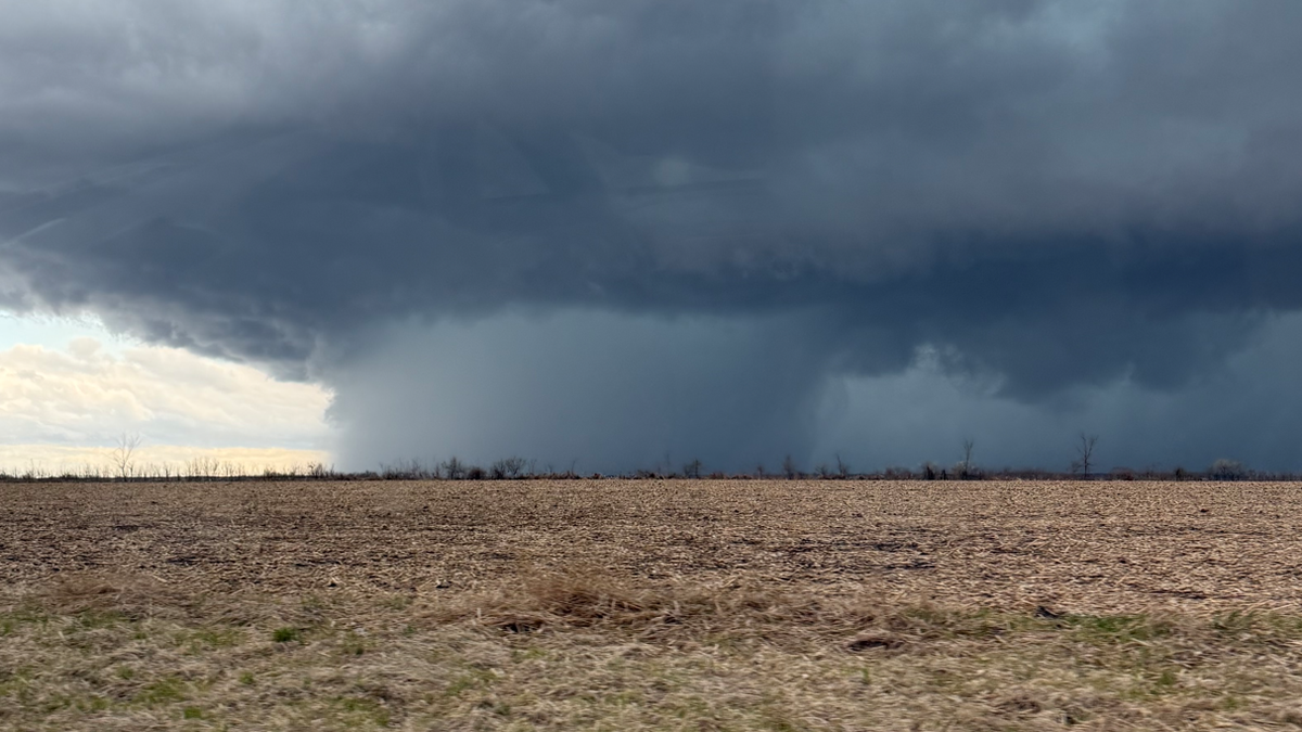
Today’s storms
Steady rain brought over an inch of rainfall to central Iowa this morning, helping to keep temperatures on the cool side. This afternoon a surge of warmer air will push into southern Iowa, helping to bring fuel for additional thunderstorms capable of at least some severe weather.

Those storms are developing in southwest Iowa as of early this afternoon, and will quickly push eastward throughout the afternoon hours. As the storms interact with the warm and humid air south of I-80, they will likely intensify with at least some risk for severe weather. Large hail and damaging winds will be the main risks, but there will be a low chance for tornadoes as well, especially over southeastern Iowa where temperatures will have longer to warm up.
This line of storms should reach the I-35 corridor between 1 and 2pm. While the storms may not be severe as they reach I-35, that will be strengthening and the severe risk will gradually increase as they push to the east.

By 5pm, this line of storms should be moving out of central Iowa, taking the risk for severe weather with them. The risk will continue over eastern Iowa for a couple more hours, before cooler and quieter weather takes over for the rest of the evening and the overnight for most of the state.
Friday’s storms
Another low-pressure system will draw warm, humid air toward Iowa Friday afternoon.

Friday’s storms are expected to form later in the afternoon in southern Iowa and northern Missouri.

Severe potential is higher Friday, thanks to more energy in the atmosphere and more favorable winds.
The highest threat is across southern and southeast Iowa, where storms will spread through into the evening.
The main thing to watch is how long it takes the warm, moist air to lift into Iowa from the south and how far north it goes before nightfall. Where temperatures remain cool all day, the severe weather risk be extremely limited, or nonexistent.
Tornado safety tips
If you are in a home, small building, nursing home, hospital, factory, shopping center or high-rise building:
- Go to a pre-designated area such as a safe room, basement, storm cellar or the lowest building level. If there is no basement, go to the center of a small interior room on the lowest level (closet, interior hallway) away from corners, windows, doors and outside walls. Put as many walls as possible between you and the outside. Get under a sturdy table and use your arms to protect your head and neck.
- If you are in a pickup line at your child’s school, get inside the building as quickly as possible.
- In a high-rise building, go to a small interior room or hallway on the lowest floor possible.
- Make sure you are wearing sturdy shoes.
- Do not open windows.
If you are in a mobile home, manufactured office building or camper:
- Get out immediately and go to a pre-identified location such as the lowest floor of a sturdy nearby building or a storm shelter. Mobile homes, even if tied down, offer little protection from tornadoes.
If you are not in a sturdy building, there is no single research-based recommendation for what last-resort action to take because many factors can affect your decision.
Possible actions (which do not guarantee safety) include:
- Immediately get into a vehicle, buckle your seat belt and try to drive to the closest sturdy shelter. If your vehicle is hit by flying debris while you are driving, pull over and park.
- Take cover in a stationary vehicle. Put the seat belt on and cover your head with your arms and a blanket, coat or cushion if possible.
- Lie in an area noticeably lower than the level of the road and cover your head with your arms and a blanket, coat or cushion if possible.
Understanding the Enhanced Fujita Scale
The National Weather Service uses the Enhanced Fujita Scale, or EF-Scale, to assign tornado ratings based on estimated wind speeds and related damage.
The Enhanced Fujita Scale, which replaced the earlier Fujita Scale in February 2007, categorizes tornadoes by degree of damage indicators and associates that damage with estimated wind speeds for three-second gusts.
Enhanced Fujita Scale levels
- EF0 (weak): 65-85 mph wind gusts
- EF1 (weak): 86-110 mph wind gusts
- EF2 (strong): 111-135 mph wind gusts
- EF3 (strong): 136-165 mph wind gusts
- EF4 (violent): 166-200 mph wind gusts
- EF5 (violent): Over 200 mph wind gusts